Introduction
The science of remote sensing involves acquiring data about objects in our environment or phenomenon without making any physical contact with it. This process is carried out by sensing and recording reflected or emitted energy from the objects and processing and analyzing the data collected.
There are two types of sensors used in remote sensing — active and passive. The sensors which measure energy from the naturally available sources are passive, while active sensors use their energy source for the illumination of objects. The sensor emits radiation which is directed towards the target objects to be examined. The radiation mirrored from that target is detected and measured by the sensor. The advantages of active sensors are the ability to obtain measurements at any time of day or season. RADAR (Radio Detection and Ranging) and LiDAR (Light Detection and Ranging) are examples of active remote sensing sensors.
LiDAR is an optical remote sensing technology that uses ultraviolet, visible, or infrared light and measures the distance to or other properties of the object with reflected laser light. Airplanes and helicopters are the most commonly used platforms for acquiring LiDAR data.
LiDAR data are of two types — one is topographic LiDAR that typically uses a near-infrared laser to map the land cover. At the same time, the other is bathymetric LiDAR, where water penetrating green light is used to measure seafloor and riverbed elevations.
One of the advantages of a laser is that it has a very narrow beam that remains concentrated over long distances. Because shorter wavelength lasers are modulated much faster. On the other hand, RADAR releases energy in many directions; its diffusion weakens the energy. LiDAR measures target range from the time delay of the laser pulses and have three components — laser ranging sensor, precision global positioning system, and Inertial Measurement Unit.
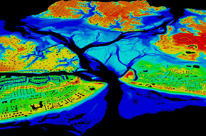
LiDAR measures vegetation coverage and canopy height from the vertical profile of the received pulse waveforms is shown in Figure 1.
Multiple echoes are possible from each pulse, and better target resolution can be achieved with shorter pulses. For this to work the LiDAR receiver, detectors and electronics need to have sufficient bandwidth.
Applications of LiDAR in Natural Resource Management
LiDAR data requires exceptionally accurate timing and fast computation. It has been primarily used to measure the distance of the aircraft from the ground; and for police to track the speed of vehicles. However, its usage by space agencies is well documented, such as the LVIS (Land Vegetation Ice Sensor), which is a full-waveform airborne LiDAR with a vast swath imaging laser altimeter system that flows over target areas to collect the data. Also, ICESat (Ice Cloud and land Elevation Satellite series) that carries GLAS (Geoscience Laser Altimeter System) and collects the data of global cloud cover, vegetation canopy, and polar ice caps, to name a few.
Commercially, LiDAR has not been a popular sensor due to the complexity of image processing, limited data acquisition opportunities, and lack of know-how on the applications of LiDAR remote sensing.
Some of the most exciting use cases specific to natural resource management are as follows:
- Topology mapping.
- To help farmers understand which areas of their fields to apply fertilizers to achieve higher crop yields.
- For forestry, canopy height, biomass measurements, and leaf area studies.
- To create very high-resolution Digital Elevation Models(DEM)
- To produce more accurate shoreline maps.
Applications of LiDAR in Atmospheric Studies
Another type of application for space-based LiDAR is atmospheric studies. For example, Differential absorption LiDAR (DIAL) is used to measure the total column of atmosphere absorption by specific atmospheric gas such as methane by comparing the online and offline wavelengths of the gas absorption line. LiDAR can also be used to measure clouds, aerosol, water vapor and temperature, watershed, and conduct river surveys.
Applications of LiDAR in Autonomous Vehicles
Autonomous vehicles are touted to be the next big technology innovation, with giants like Google, Apple, Amazon working on the prototypes. LiDAR interestingly is the choice of imaging. This is because fusing the radar data with LiDAR measurements can provide valuable information about the dynamic properties of the obstacle. This could be data like the velocity and location of the obstacle for the sensor location. This, in turn, helps the vehicle or the driver decide the action to be performed to ensure safety. Hence, autonomous vehicles use LiDAR data for obstacle detection, which is the most critical element of their success.
LiDAR technology is still evolving in ground-based, airborne, and space platforms, and we hope to see many more applications of it soon.
[Written by Praveen Kumar Kokkerametla, AVP- Remote Sensing Operations, SatSure. This story was first published on our Medium blog.]
References:
NOAA. What is lidar? National Ocean Service website,
https://oceanservice.noaa.gov/facts/lidar.html, 02/26/21.