
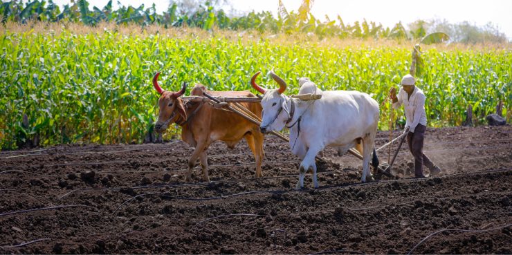
Accurately assessing crop productivity is critical for accurate production estimates. To ensure accurate estimates of average yields per hectare and total production of crops in a state, State Governments rely on crop estimation surveys, usually done through a physical documentation process. Crop survey data is necessary for a State Government to design policies around input allocation, fertilizer distribution, irrigation management, subsidy planning, market reach, budget allocation, and investment support scheme. The Government wants to facilitate the adoption of improved technology, effective extension reach & mechanization, marketing tie-up, adequate credit, and crop insurance provided to the farmers.
This Case Study explains how SatSure collaborated with the Telangana government to foster the remote digitization of farmlands and create a digital crop registry by leveraging geospatial intelligence. Understand how we used SatSure Sparta Maps to create the first step towards digital transformation for the State Government of Telangana.
The Challenge:
As per the official website of the state, the total geographical area of the state is 114.84 lakh hectares; out of the total geographical area, 40.5 per cent is under net area sown, 23.9 per cent is under forests, 10.5 per cent is under current fallow lands, 7.7 per cent is under non-agricultural uses, and 5.4 per cent is under barren land uncultivable land.
The state’s farming ecosystem was riddled with unstructured & asymmetrical datasets, making it difficult to keep accurate crop yields and farm income records. The lack of data standards and digital frameworks leads to restricted or limited data points and data transparency problems, posing a substantial impediment to efficiency and precision.
Another barrier was the manual process of data collection followed by the maintenance of essential documentation in physical (paper) form. In most developing countries, this process often relies on old Government records for assessing insights on farmlands, including cultivable areas and historical performance. The physical documentation and verification are expensive, time-consuming, cumbersome, and highly susceptible to human errors.
The Agricultural Ministry of the Telangana government required extensive ground data from agricultural fields for crop registration. They also needed continuous monitoring of the crops through the season at varying granularities, including farm, village, taluka and clusters.
SatSure’s Value Proposition
To solve the problems mentioned earlier, SatSure Sparta Maps facilitates three critical areas:
- Build a Decision Support System for the Government of Telangana
- Bring synergy to activities of multiple stakeholders and ensure optimum utilization of resources
- Make the Agricultural sector optimized, sustainable and profitable
We proposed four components of the digital transformation process. With a unified model across policy and technology, it is much easier to achieve future goals at scale for a Government organization.
Four Pillars of Digital Transformation Through SatSure Sparta
- Innovation: Our Business intelligence tool enables the stakeholders with the right information at the right time. The application tackles the 3Vs of Big Data- Velocity, Volume and Variety.
- Collaboration: The adoption of the Digital Farm Registry enables collaboration within the ecosystem as there will be information flow both ways, i.e. from farmer to Government and vice versa
- Operational Excellence: Transparent information flows help optimize the processes, which allows organizations to achieve operational excellence
- Information and Insights: Each stakeholder can access timely information and actionable insights backed by scientific methodologies.
Our Solution:
Digitization of such a vast area and fragmented land holdings will require a phased implementation approach.
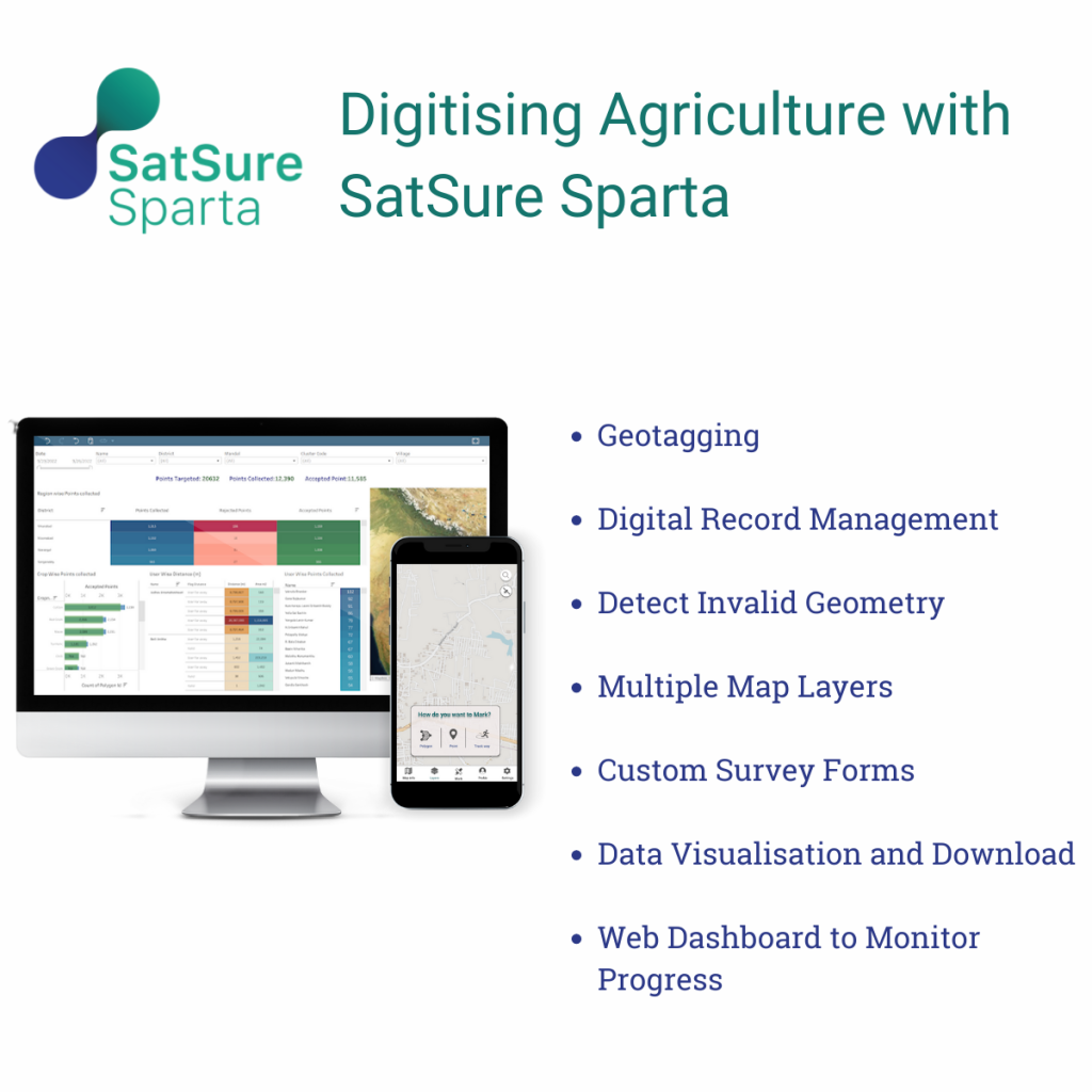
Our first step was to create the digital crop registry. SatSure Sparta Maps has features like
- Geofencing
- Digital farmer and farm record management
- Digital package of practices
To enable digitization at scale, human resource involved in the activity has to be trained to test and use the application for a high success rate. We conducted extensive training sessions for the state’s agricultural extension officers and other government officials. It helped the state Government create a digital crop registry, marking the first step towards digitization and rendering efficient resource allocation for the farming community.
Methodology adopted by Government of Telangana and SatSure:
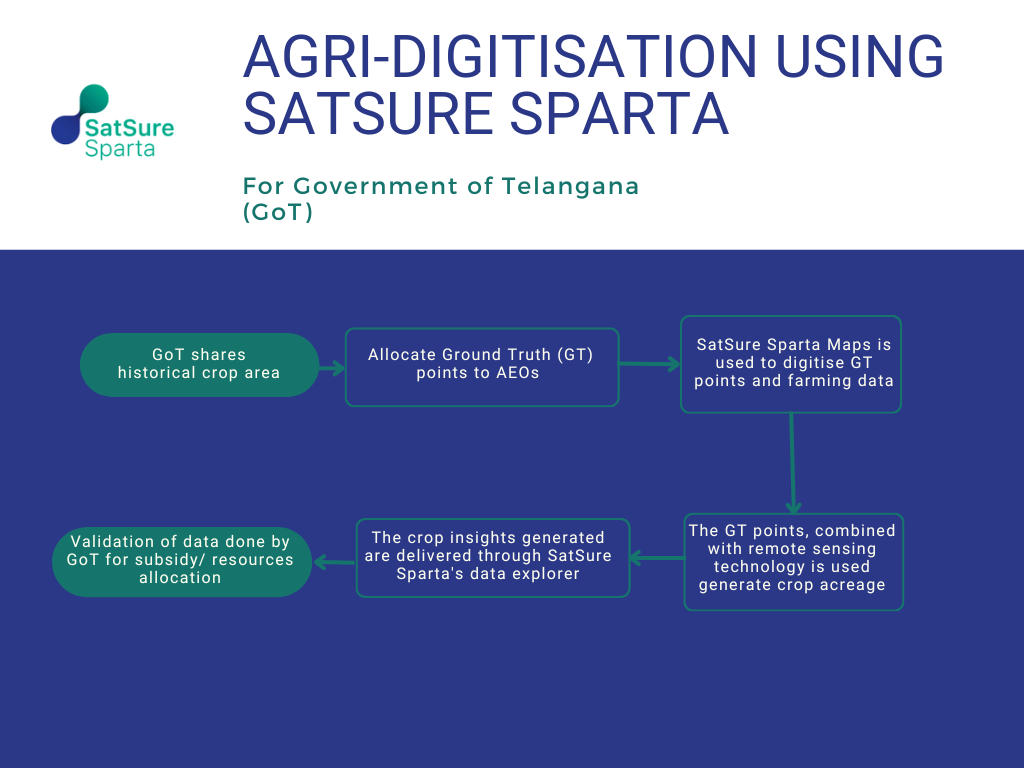
This flow chart depicts the methodology adopted by the government of Telangana and SatSure to meet the goals set for digital transformation for each farm in the State.
Key Benefits:
- Accurate Field Data Collection
SatSure Sparta Maps enables accurate data collection for farm areas. It promotes standardization of data and aids in the elimination of the time-consuming manual data collection, which is manually done in physical paper documentation. SatSure Sparta Maps comprises a simple user interface (UI), including user guides for direct consumption, deployment and usage.
- Quick Access to Crop Insights
This aspect helps mitigate information asymmetries for individual farmers and the Agri-Department of the state Government. Users can access the spatial data layers on their mobile devices; hence, the department can enhance their on-field team’s productivity and efficiency.
- Digitization of farm boundaries
The relevant extension officers received the requisite training for using the application. It enables the Government to have a repository of farm details, crops grown, farm area, and owner details allowing quick disbursement decisions on inputs and subsidies.
Impact:
- Over 2500 agriculture extension officers (AEO) are trained and are active on SatSure Sparta Maps.
- Digitized crop booking activity for all 32 districts for the state of Telangana.
- Standardized data: district and crop-wise, crop sown area, and crop acreage estimates for the entire state.
- We reduced the crop survey activity using remote sensing technology from months to a week, minimizing human intervention and increasing accuracy.
Conclusion:
After successfully delivering the crop area estimates for both the Rabi and Kharif seasons while achieving the required accuracy levels, we are now taking this forward for the following seasons with the Government of Telangana.
The next step was to help the state Government with access to satellite remote sensing data crop insights across the cropping cycle. SatSure Sparta Maps allows to visualization of crop data generated with satellite remote sensing, which can be overlayed on a spatial map. The granularity of the data was at the village, taluka and district levels, allowing a transparent insight into the crop condition at any stage of the season.
We are going to release some key new features for SatSure Sparta Maps.
Click here to subscribe and learn more about our offerings.


Add comment