
Japan experienced its deadliest quake in nearly eight years, with a devastating 7.6 magnitude, on January 1, 2024. This was followed by a magnitude 6.0 quake on January 9, 2024, claiming 100 lives and leaving more than 200 people missing. The aftermath of the earlier disaster has left 23,000 homes without power in the Hokuriku region, with rescue efforts ongoing as the death toll continues to rise.
Looking back at 2023, the world experienced some major earthquakes including series of earthquakes in Afghanistan. Using several reports, we have illustrated some major earthquakes in 2023 and its impact in the regions.
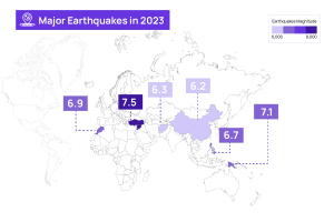
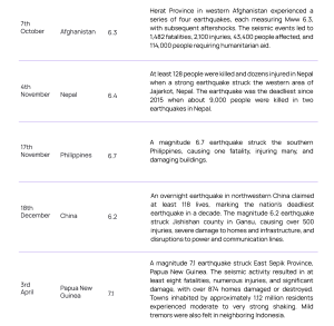
A glimpse into the major Earthquakes in 2023 across the world
 .
. 
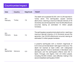
Impact of the earthquakes along with the timeline in 2023
Impact of the Series of Earthquakes in Afghanistan
On 7th and 11th October, 2023, two significant earthquakes, both registering a magnitude of 6.3, struck Herat province in western Afghanistan. Moreover, a series of aftershocks continued until October 14, including dust storms reported on October 12th that wreaked havoc in six districts damaging tents used by health mobiles and nutrition teams (MHNTs), leaving the local population in a constant state of anxiety and fear.
This makes the situation even more challenging for rescue teams to locate the exact areas affected and navigate the rescue team towards the victims. Take a look at the Factbox below, detailing a series of earthquakes that occurred in Afghanistan in 2023.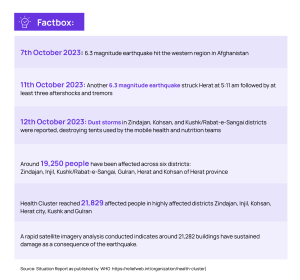
The Role of Satellite Remote Sensing for Disaster Management and Mitigation
In the face of such natural calamities, time is of the essence, emphasizing the urgent need for rescue teams to ensure timely delivery of critical supplies such as medicines, medical aid, food, and other necessities.
A quick disaster assessment with hyper-local accuracy is essential to pinpoint the exact location for subsequent rescue operations. The speed with which we derive inference is crucial for providing rapid relief to victims and guiding the rescue team in supplying medicines and planning relief measures.
SatSure Skies conducted an independent study for damage assessment, utilizing data intelligence from space through high-resolution satellite imagery.
We used the following datasets to analyze the region and assess the physical impact of the earthquake:
- Building footprint (polygons)data : Humanitarian OpenStreetMap(source)
- Image Source: Pléiades (Satellite), 50cm data
The pre-event image used for the analysis was for the timestamp 2023-10-20T07:12:14.000Z and the post-event image: 2023-10-19T12:14:13.000Z. The input channels used were Red, Green, Blue ( RGB).
NOTE: Since the capture of both the images are at different angles, resulting in the difference in the shadows falling at different places. Hence, it is sometimes difficult to see certain objects such as walls when the color of the ground is the same as the object. While analyzing building polygons in pre and post it is seen that after the earthquake occurred, there’s a shift in the terrain.
Recommendations and Actionable Insights from Satellite Imagery
While SatSure’s damage assessment solution utilizes satellite imagery to offer insights into potential earthquake damage on infrastructure and property, it has certain limitations as highlighted below:
- Only major physical damages can be captured with satellite imagery
- Minor rooftop or structural damages can sometimes be missed out by using solely satellite imagery
- Any internal damages to the property or infrastructure cannot be analyzed with satellite imagery
Let’s deep dive into how satellite or aerial imagery support during such a natural disaster.
Any natural disaster goes through a pre-event preparedness, mitigation and post-event management. The image below highlights the key areas around disaster preparedness:
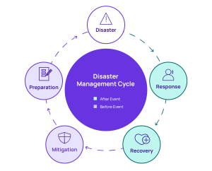
Disaster Management Cycle
For natural calamities like earthquake, floods, cyclones etc. access to historical satellite imagery and land use land land cover analysis (LULC) can provide insights into potential areas which can be impacted maximum by an event. Few other datasets that integrate into this decision making are digital elevation models (DEM), existing earthquake fault lines, existing infrastructure and the impact of previous natural calamities through frequency and intensity of the event. Such analysis can help in creating risk zones (high, medium and low) for proactive planning before an event.
Post Event Analysis
For post event analysis, even if actual damage sometimes becomes difficult to analyze, the importance of agility in decision making for the disaster action and rehabilitation is of paramount importance.
Hence, while using a simple 3R framework can optimize rescue operations –
- Reaching the Right Location
- With the Right Time
- With the Right Plan
Above mentioned 3R framework can help stakeholders and government bodies to take quicker actions. A simple scenario is analyzing the intensity and maximum damage areas with high population density can become a very high priority zone for resource deployment and action.
To understand how satellite imagery can support in different natural calamities, read our previous articles highlighting the analysis, action plan and impact:
The recent event of natural earthquakes around the world, gives enough validation on why satellite imagery analysis is the most effective and efficient solution for disaster management and insurance. To access in-depth analysis of how Satellite image is transforming the solution landscape for disaster management, reach out to us at: info@satsure.co


Add comment