
The commercialization of the downstream sector in the last decade has helped expand the applications of satellite remote sensing beyond Government projects and defense applications. Today, with a wide range of applications spread across diverse areas like agricultural inputs, agriculture commodity trading, fast-moving consumer goods (FMCG) credit lending, infrastructure, disaster management, and many more, satellite imagery analytics has transformed the way businesses make decisions.
In this ecosystem, to gain a competitive edge, businesses around the world are struggling to find affordable and analytics-ready datasets derived from satellite imagery. While many applications today are driven through open-source satellite imagery available at low resolution, commercial high-resolution imagery tends to be expensive, especially for agriculture applications, where the area to be monitored is large and margins are low.
The Complexity of Choosing the Right Satellite Imagery
Choosing the right Earth Observation (EO) satellite imagery for your specific business application is the first and most important step. It will define the kind of insights that you will generate and determine the project costs, which directly impacts your overall budget, project scope, and parameters of decision-making.

The EO satellite data can be categorized into two segments depending on the commercials involved:
- Open Source Satellite Data
- Commercial Satellite Data
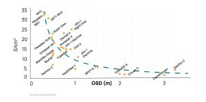
Figure 1: Costs of high resolution data compared for different resolutions (Source: Euroconsult)
While open-source satellite data is available at 10 m and lower resolution, its applications are limited since it becomes difficult to generate insights with them at the farm level.
In the case of commercial EO satellite data, which comes at medium and high resolution, the project cost needs to account for Satellite data costs, which is an additional factor to the application development and services cost.
One may ask, why should costs matter?
The market requirement of large-area natural asset monitoring for agriculture and forestry is significantly price-sensitive requiring large-area coverage and monitoring. The EO satellite operator’s data pricing models make it significantly difficult to scale projects in these sectors.
SatSure Super Resolution: Enhancing Spatial Resolution for Better Insights
We have been operating in the downstream applications sector since 2017, and have faced the same challenges. To solve the data costs challenge, we developed the SatSure Super Resolution, a deep learning model that enhances the spatial resolution of Sentinel-2 imagery by fourfold. The imagery is transformed from 10 meters to 2.5 meters while preserving structural, perceptual, and spectral characteristics.
This data product has demonstrated consistent results, improving the productivity of both manual analytics and automated downstream tasks. Applications such as Land Use Land Classification (LULC), Farm Boundary, and Crop Classification among others at a fraction of the cost of commercial EO datasets.
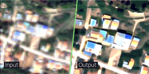
Figure 2: An area of interest enhanced by 4x using SatSure Super Resolution
Delivering Business Impact with SatSure Super Resolution
The advantages of using SatSure Super Resolution traverse beyond the cost savings. We have highlighted three important factors that any organization using EO satellite data will benefit from.
A. Cost Efficiency: Get a 75% cost reduction compared to commercially available medium and high-resolution optical satellite imagery while maintaining comparable spatial resolution.
B. Versatile Applicability: SatSure Super Resolution data finds utility across a spectrum of sectors, including agriculture, forestry, environmental monitoring, urban planning, and scientific research, making it a versatile solution for diverse applications.
C. Enhanced Analytical Precision: By utilizing SatSure Super Resolution decision-makers gain access to significantly enhanced detail and accuracy in analytics through granular pixel information, and accurate boundary and feature identification.
SatSure Super Resolution can enable your remote sensing teams and organization to build better insights across applications like agriculture, forestry, environmental monitoring, urban planning, disaster management, and beyond.
To learn more about SatSure Super Resolution, download our comprehensive whitepaper. Reach out to us at info@satsure.co or book a demo with us.


Add comment