
In our previous blog, we explored how SatSure Super Resolution is enabling valuable insights without impacting your budgets. We dived deep into the transformative impact of the commercialization of the downstream sector, and how satellite imagery has propelled beyond its traditional applications in government and defense to various industries such as agriculture, FMCG, and disaster management.
As satellite data is rapidly becoming the key to success for many industrial verticals, businesses across the world today face challenges in acquiring affordable, high-resolution satellite imagery for better insight generation leading to better decision-making. The complexity of choosing the right Earth Observation (EO) satellite imagery for the right use case is crucial for determining project costs and insights generation.
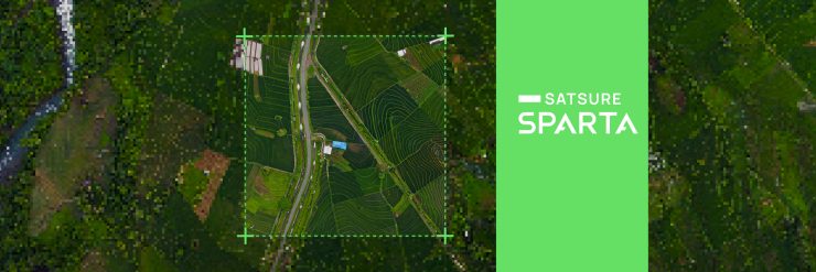
SatSure addresses these challenges with SatSure Super Resolution. It is a deep learning model that can enhance the spatial resolution of Sentinel-2 from 10 meters to 2.5 meters while preserving structural, perceptual, and spectral characteristics while reducing the satellite image acquisition cost by 75%.
SatSure Super Resolution: Enhancing Spatial Resolution for Better Insights Generation
SatSure Super Resolution has demonstrated consistent results across different applications, improving the productivity of both manual analytics and automated tasks. Applications such as Land Use Land Classification (LULC), Farm Boundary, and Crop Classification among others can be carried out at a fraction of the cost of commercially available high-resolution EO datasets.
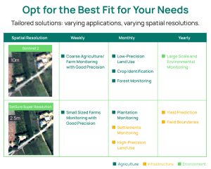
As we delve into practical applications, let’s explore specific use cases where users can harness SatSure Super Resolution imagery to gain valuable insights without straining their budgets. Take a look at some of the diverse use cases of SatSure Super Resolution and how they can best fit your specific needs.
Agriculture
Enhanced Crop Classification
The Traditional Approach:
Open-source low-resolution satellite imagery, like data from Sentinel-2, is commonly employed for monitoring crops across extensive areas. However, due to the 10m spatial resolution of Sentinel-2, capturing finer details on individual farms becomes challenging, leading to a lack of crucial insights at the granular level for decision-makers. Additionally, the traditional manual approach comes with its own challenges, such as:
- Crop classification using remote sensing software demands highly trained professionals.
- Crop classification at low resolution falls short of generating granular-level insights at a plot level.
The SatSure Super Resolution Effect:
In contemporary methods, machine learning (ML) is extensively employed for crop classification, with model accuracy heavily reliant on input data quality—where optical satellite imagery plays a crucial role in large-area analysis. SatSure Super Resolution, enhancing spatial resolution by 4 times, enables the same Sentinel 2 imagery to capture finer details, thereby enhancing the accuracy of ML models. Enabling easily monitoring for even small-sized farms, which is a limitation with 10 m and other lower-resolution satellite imagery.
Accurate field boundary delineation
Farm boundary delineation serves as a foundational layer in the agricultural industry, playing a crucial role in supporting various solutions and applications. It involves the accurate mapping and identification of the boundaries of agricultural fields.
The Traditional Approach
In traditional practice, the usage of low-resolution satellite imagery becomes suboptimal for accurate farm boundary delineation for small and medium land holdings. This limitation necessitates the use of field surveys for manual geo-tagging and boundary delineation. An alternative but expensive solution involves manually delineating farm boundaries using high-resolution satellite imagery. Challenges associated with these approaches include:
- Lack of precision and accurate farm boundary due to high manual interventions
- Expensive and time-consuming operations
- Inefficiency of covering larger areas
The SatSure Super Resolution Effect
At SatSure, to enhance the accuracy of our ML model for farm boundary delineation, we utilize Sentinel-2 imagery with a 10m spatial resolution as the input image. This imagery is processed through the SatSure Super Resolution model, increasing the spatial resolution by four times. The resulting enhanced imagery enables the capture of finer details. Following this, our Automated farm boundary delineation model is applied to the super-resolved imagery. The transition to this input imagery yields a 5 times improved output data compared to that derived from Sentinel-2. Discover more on the Automated Farm Boundary Delineation by SatSure in out comprehensive whitepaper.

Infrastructure
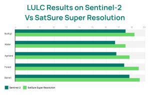
Land Use Land Classification (LULC)
Land Use and Land Cover (LULC) information is widely used across various disciplines for diverse applications. LULC maps find their use case in planning and designing infrastructure projects, including transportation networks, energy facilities, and urban infrastructure. It ensures that development projects align with the existing land cover characteristics.
The Traditional Approach
The traditional approach of generating LULC relies on a combination of satellite imagery interpretation, manual classification, and validation to produce accurate and reliable Land Use and Land Cover maps for various applications, including urban planning, environmental monitoring, and natural resource management. However, the traditional practices have witnessed significant challenges as:
- Lack of precision and accurate data due to high manual interventions
- Difficulty in accurately classifying transitional zones lead to misclassifications
- Businesses needing precise LULC data, utilizies commercially available high-resolution data and incur high operational costs.
The SatSure Super Resolution Effect
LULC is dynamic in nature and hence needs a constant updation. Modern businesses utilize machine learning (ML) models to automate this process, where the accuracy of the output is highly dependent on the quality of input images. By leveraging SatSure Super Resolution, businesses can save up to 75% on high-resolution image acquisition costs while still achieving comparable output quality.
This helps the model to segregate and determine the characteristics of each class, leading to improved accuracy and performance in tasks such as land classification, environmental monitoring, and urban planning.
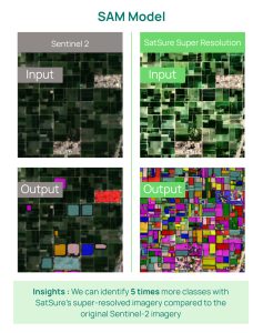
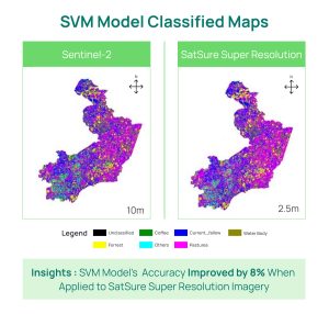
An accuracy analysis conducted using a UNet-based algorithm on classified layers obtained from both super-resolution and Sentinel-2 imagery reveals a 10% increase in the UNet model’s accuracy when applied to Super-resolved Imagery.
Forestry
Deforestation mapping
As regulations such as the European Union Deforestation Regulation (EUDR) become a necessity within commodity trading, the need for robust and comprehensive deforestation analysis has become essential. To comply with regulation standards, the importance of thorough assessments of the environmental impact and sustainability of the traded commodities has heightened significantly.
The Traditional Approach:
Traditional forest mapping comprises of LULC analysis combined with crop classification on satellite imagery typically performed using sourced low-resolution data that delivers macro-level results. However, for specific compliance requirements like EUDR, detailed examination of historical data is needed to identify deforestation at the plot level. Here low resolution imagery proves to be inadequate. Some additional challenges involve:
- Lack of detail required to accurately segregate different tree and plantation types.
- At low resolution granular analysis and generating insights at a plot level is not possible.
The SatSure Super Resolution Effect:
The new age forest mapping approach through LULC involves the usage of deep learning models such as SatSure Super Resolution which helps in accurately classifying forest areas, forest types, and even tree/ plantation types, with the combination of ground truth data.
By capturing fine-scale features with greater precision, SatSure Super Resolution imagery enables more accurate identification and classification of tree species and plantations. Enabling accuarte temporal analysis at plot level to detect deforestation.
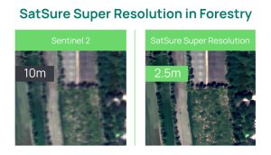 Application of SatSure Super Resolution in forestry
The possibilities, thus, are endless with SatSure Super Resolution. The combination of open-source data and enhanced precision with SatSure Super Resolution allows for increased frequency in monitoring and thus holds the key to the future of earth observation-geospatial data analytics to help businesses dive into informed decision-making.
Download the SatSure Super Resolution Whitepaper to understand how your business can harness the potential of SatSure Super Resolution.


Add comment